Introduction
In design and construction, while figuring out the building technology that may be used — the most important factor to start with is the climate region of the area. Building science, energy code, and residential design in general is greatly influenced and referenced to these climate zones. They also control specifics such as where to locate (if any) vapor barrier in a wall assembly. Understanding these 8 climate zones is imperative to implementing best practices and creating an efficient and performing design.
Varying Definitions
There are many different organizations and governing bodies that have produced many different definitions. This page organizes and categorizes (generally and roughly speaking) what Architects need to know in the US for energy code and building technology.
Classification International Energy Conservation Code (IECC) & Pacific Northwest National Laboratory (PNNL)
In the early 2000s, the PNNL made an effort to categorize and simplify climate zone definitions so that all the various groups could come to a consensus and refer to the same map when dictating energy code and requirements. This map was based on weather readings from almost 5,000 weather stations, and is now widely used and published as part of the IECC.
This simplified map identified 8 temperature oriented climate zones, as well as being able to identify each zone as 3 separate climate regimes. Together, this creates the theoretic ability for 24 different designations (8 * 3 = 24) — In reality not all definitions are used.
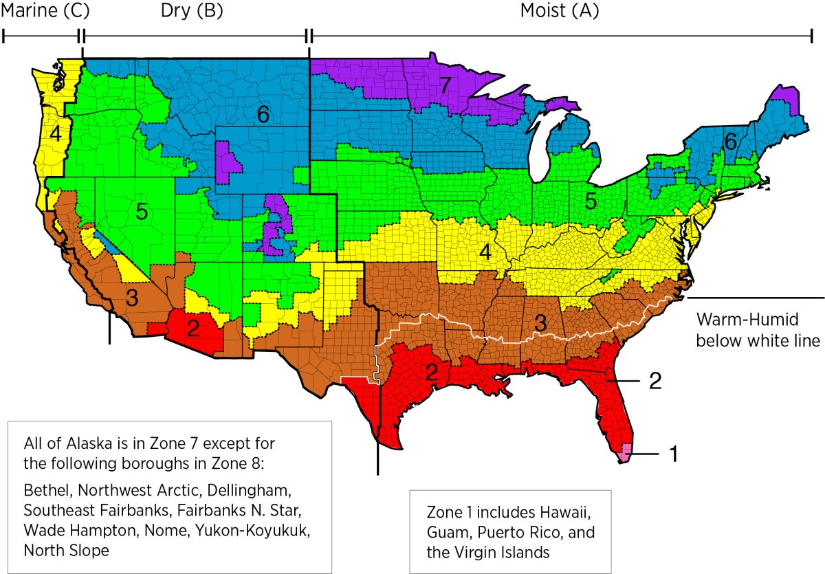
Climate Zones
Zones listed below; government definitions are taken from US Government Energy Text.
- Criteria for how each A, B, C zone is determined is found in Table C301.3(1)
- Criteria for how each zone is determined is found in Table C301.3(2)
Table C301.1 has a full list of all areas in the US broken down by State, County and Territory.
Zones By #
Zone 1-2 (Very Hot-Humid)
Zone 1 gets a good amount of rain, along with wonderful humidity. Pretty much exclusively on the South tip of Florida, they get long summer days with plenty of heat. Really never will get cold in this zone in any significant way.
Government Definition
A hot-humid climate is generally defined as a region that receives more than 20 in. (50 cm) of annual precipitation and where one or both of the following occur:
- A 67°F (19.5°C) or higher wet bulb temperature for 3,000 or more hours during the warmest 6 consecutive months of the year; or
- A 73°F (23°C) or higher wet bulb temperature for 1,500 or more hours during the warmest 6 consecutive months of the year.
Zone 2-3 (Hot-Humid)
Zone 2 gets a good amount of rain, and they have lots of hot days. These areas are great vacation spots for Northern folk looking for consistent and regularly hot weather. Southern parts of Georgia, Arizona, Texas and the rest of Florida fall into this zone. With climate change, some areas may experience ice storms and ‘abnormal’ cold weather through the polar vortex.
Government Definition
A mixed-humid climate is generally defined as a region that receives more than 20 in. (50 cm) of annual precipitation, has approximately 5,400 heating degree days (65°F basis) or fewer, and where the average monthly outdoor temperature drops below 45°F (7°C) during the winter months
Zone 3-4 (Hot-Dry)
Zone 3 is hot and dry, essentially a desert. They get minimal precipitation, and a lot of heat. This is a lot of Texas, Mississippi, Arkansas, Alabama, South Carolina, and Georgia. Most of zones 1-3 have no use for heating, but that has recently become an issue with global weather trends changing.
Government Definition
A hot-dry climate is generally defined as a region that receives less than 20 in. (50 cm) of annual precipitation and where the monthly average outdoor temperature remains above 45°F (7°C) throughout the year.
Zone 4-5 (Mixed-Dry)
Climate Zone 4 is Mixed-Dry and a bit of a confusing place to live and build. This zone doesn’t get a lot of annual precipitation so humidity, snow, and rain are not huge worries. But it can still get hot during the summer, and reasonably cold in winter. Exceptions to this is in Marine C group which may get lots of precipitation.
Government Definition
A mixed-dry climate is generally defined as a region that receives less than 20 in. (50 cm) of annual precipitation, has approximately 5,400 heating degree days (65°F basis) or less, and where the average monthly outdoor temperature drops below 45°F (7°C) during the winter months.
Zone 5-6 (Cold)
Zone 5 is more Northern and therefore it stays colder in general. The zone has a summer, but that summer never gets too hot historically. They also have longer and typically snowy, cold winters with lots of below zero days, wind chill, and polar vortexes.
Government Definition
A cold climate is generally defined as a region with approximately 5,400 heating degree days (65°F basis) or more and fewer than approximately 9,000 heating degree days (65°F basis).
Zone 6-7 (Very-Cold)
Zone is very cold and a large part of the Northern US. The people that live in these locations enjoy a very short but typically pleasant warmer months where none of the days get anywhere close to hot, while the winter can seem like it is never ending and bitterly cold. A/C use in these regions is typically limited to a few months of the year.
Government Definition
A very cold climate is generally defined as a region with approximately 9,000 heating degree days (65°F basis) or more and fewer than approximately 12,600 heating degree days (65°F basis)
Zone 7-8 (Subarctic)
Zone 8 is extremely cold. This zone is the very North parts of the country along with some areas where higher elevations make the weather unseasonably cold for the region. Most of Alaska is zone 7 as well. A/C use would be minimal or non-existent in most homes.
Government Definition
A subarctic climate is generally defined as a region with approximately 12,600 heating degree days (65° basis) or more.
Zones A,B,C
Zone A (Moist)
Zone A is everything East of Zone B. It encompasses the interior plains, the Appalachian mountains and all of the East coast along the Atlantic Ocean.
Zone B (Dry)
Dry zone is everything East of Zone C and West of Zone A. It encompasses the Colorado plateau, the Rocky Mountains, and all the US major deserts including Great Basin, Mojave, Sonoran, and Chihuahuan.
Zone C (Marine)
The West Coast along the Northern Pacific Ocean is entirely Marine. Warm ocean breezes and currents help make the area relatively moderate year round, even in further North latitudes.
Government Definition
A marine climate is generally defined as a region that meets all of the following criteria:
- A mean temperature of coldest month between 27°F (-3°C) and 65°F (18°C)
- A warmest month mean of less than 72°F (22°C)
- At least 4 months with mean temperatures more than 50°F (10°C)
- A dry season in summer. The month with the heaviest precipitation in the cold season has at least three times as much precipitation as the month with the least precipitation in the rest of the year. The cold season is October through March in the Northern Hemisphere and April through September in the Southern Hemisphere.
Warm Humid
Warm Humid is another zone without a letter assigned but further divides the Moist A area (and a tiny portion of Dry B area) in the South. This includes all of Florida and many of the Southern states such as Louisiana, Alabama, Mississippi, Georgia and lots of Texas.



Leave a Reply
You must be logged in to post a comment.